User Guide
Navigation within the map
Neu0’s interactive snow maps are accessible via the menu or by clicking on the home page corresponding areas. Each map is restricted to a geographical area depicted as a green rectangle further referred as a “massif”.
The user can navigate in the interactive map. On a computer, panning and view angle are controlled with the mouse by holding the left or right button. The mouse scroll allows to zoom. On a touchscreen, one finger is used to pan. Two fingers are needed for zooming or for modifying the view angle. When the viewing pitch is modified, the relief appears in 3D. The pitch is modified with a mouse vertical movement while holding the right button. On a touchscreen, two fingers with a vertical movement will reveal the relief.
A search widget at the upper left allows to find a location by entering its name. Only places in the vicinity of the massif are reachable.
For each massif, the user can display the snow cover estimate for several dates. The date selector button is in the upper left corner, just below the search widget. The most recent estimate and some archive data are available. The user can hide the snow layer by clicking on the snowy peaks icon next to the date selector button.
Snow cover representation
Snow is displayed by a white layer whose opacity represents the cover fraction estimate, i.e. the percentage of ground covered by snow over a limited area. Opaque white represents a 100% snow cover fraction. To date, only the snow cover fraction is available. Research is underway to improve the neu0 service and display other parameters such as snow depth or snow condition, using existing satellites or those to be launched in the coming years.
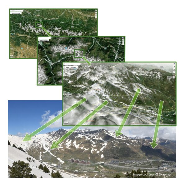
The following illustration shows a neu0 snow map and a webcam image taken on the same day. This scene includes a variety of snow cover, ranging from 100% to bare ground.

In the transition areas, the snow cover is represented as white patches of different transparency. Careful observers will notice a number of under-detections, i.e. areas with snow on the webcam image that are not represented on the map. Under-detection usually occurs on thin strips of snow or in wooded areas. Over-detection may also occurs, and generally happens when some clouds are misinterpreted by the neu0 system as snow. The maps displayed by neu0 are not direct sensor images, but the result of an estimation based on satellite sensor data. They may contain errors. We are working to reduce these errors as much as possible.
Additional controls
Several control buttons are located in the upper right corner of the map. To date, these controls allow to locate itself on the map, switch between symbolic and satellite basemaps and import a GPX track.
The snow cover estimate is displayed on top of a symbolic basemap with four colors, for forests, low vegetation, rocks and urbanized areas, or on a satellite basemap. The satellite basemap is a mosaic of high resolution satellite images acquired when the snow cover extent is reduced. Ideally, the satellite basemap should be completely free of snow, but for some areas that are snow covered for a large part of the year, this is not always possible. Users are encouraged to toggle between the symbolic basemap and the satellite basemap, by clicking on the satellite icon.
The GPX icon allows the display of a GPX track previously saved on the user’s terminal. After selection, the user is prompted to browse to the location of the GPX file to open it.
The 3D icon permits to change the camera pitch angle.
Only for users who have reached this point 😉
The name of the website comes from “nèu” which means “snow” in lenga d’òc. “0” simply alludes to the satellite trajectory around the earth.

 and then